

Comprehensive Guide to Geological Exploration: Techniques and Methods

Geophysical and Geochemical Surveys: Essential Tools in Exploration
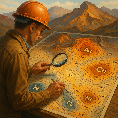
Exploration in various fields, from mining to environmental assessments, heavily relies on geophysical and geochemical surveys as essential tools for uncovering valuable insights beneath the Earth’s surface. Geophysical surveys employ specialized equipment to measure variations in the Earth’s magnetic, gravitational, electrical, and seismic properties. This data is crucial for mapping subsurface structures, identifying mineral deposits, or assessing groundwater resources.
On the other hand, geochemical surveys analyze the chemical composition of rocks, soil, water, and vegetation to understand the distribution of elements and minerals. By studying these samples, geoscientists can pinpoint areas with high mineral potential, detect environmental contamination, or even locate hydrocarbon reservoirs.
These surveys play a vital role in reducing exploration risks and optimizing resource discovery. They help companies make informed decisions, prioritize drilling targets, and streamline exploration processes. The integration of geophysical and geochemical data provides a comprehensive view of the subsurface, enabling efficient resource management and sustainable development practices.
Topographic Mapping: Precision in Mineral Resource Estimation
Key Insights and Strategies
In mineral resource estimation, topographic mapping plays a crucial role in ensuring precision and accuracy. By utilizing advanced mapping technologies like LiDAR and drone surveys, geologists can create detailed elevation models that enhance the understanding of the terrain’s topography and geological structures.
Accurate topographic maps enable geologists to identify potential mineral deposits with greater certainty, leading to more informed decisions in resource estimation processes. The integration of GIS software allows for the analysis of topographic data alongside geological information, aiding in the identification of optimal drilling locations and estimation of mineral reserves.
Step-by-Step Guide
- Step 1: Conduct a comprehensive topographic survey of the target area using LiDAR or drone technology to capture high-resolution elevation data.
- Step 2: Process the collected data to generate detailed topographic maps that showcase the terrain features and structural characteristics relevant to mineral exploration.
- Step 3: Utilize GIS tools to overlay the topographic maps with geological data, enabling geologists to interpret the landscape and determine the most prospective areas for mineral resource estimation.
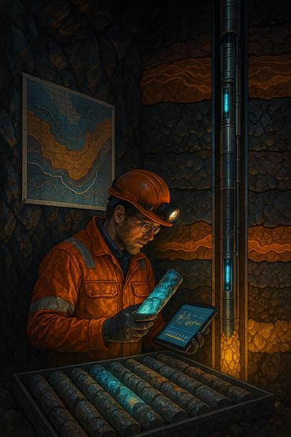
Borehole Logging and Core Analysis: Deep Insights into Geological Structures
Exploring the depths of the Earth’s subsurface, borehole logging and core analysis unveil a treasure trove of information about geological structures. By examining rock samples extracted from boreholes, geoscientists can decipher the Earth’s history, composition, and future challenges.
Unveiling Geological Mysteries
Borehole logging provides a real-time view of the underground formations, identifying valuable resources like oil, gas, or minerals. Core analysis helps in understanding the mineralogy, porosity, permeability, and fluid content within rock formations, crucial for resource exploration and environmental assessments.
Interpreting Data for Decision-Making
Accurate interpretation of borehole logs and core data is vital for making informed decisions in various industries, including oil and gas exploration, geothermal energy production, and groundwater management. The insights gained from these analyses drive strategic planning and optimize resource utilization.
Enhancing Structural Understanding
Studying geological structures through borehole logging and core analysis aids in predicting seismic activities, assessing geological hazards, and designing stable foundations for construction projects. These techniques provide a 3D perspective of the subsurface, enabling geologists to map out intricate structures with precision.
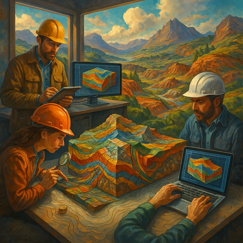
Geological Model Validation: Ensuring Accurate Representations
Frequently Asked Questions (Q&A)
Q: What’s the biggest challenge with Geological Model Validation: Ensuring Accurate Representations?
A: The main challenge often lies in reconciling the complexity of geological data with the need for precise and reliable models. Handling diverse data sources, interpretation variations, and ensuring consistency across models can pose significant challenges in achieving accurate representations.
Q: How can I make Geological Model Validation: Ensuring Accurate Representations more effective?
A: To enhance the effectiveness of Geological Model Validation, strive for comprehensive data validation, collaborate with domain experts for critical insights, implement robust quality control measures, leverage advanced software tools for modeling, and prioritize continuous refinement based on feedback and real-world validation results. These practices can significantly improve the accuracy and impact of geological model representations for better decision-making and operational success.